Ponte Vedra Beach's six areas, from Marsh Landing to South Ponte Vedra Beach: all in ZIP 32082, with zoned schools and August 2026 Zillow values.
Last checked Oct. 10, 2026. Sources: St. Johns County’s GIS open data (Ponte Vedra Zoning District, overlay district, ZIP code, address, park and architectural review association layers), the St. Johns County School District’s 2026-27 zone map, the Florida Department of Education’s 2026 school grades, Zillow Research, the Census Bureau’s TIGERweb and QuickFacts, and OpenStreetMap.
Ponte Vedra Beach is not a city, so it has no city neighborhoods. What it has instead are the lines that St. Johns County and the Census Bureau draw: a historic zoning district, two Census areas, county overlay districts and the outlines of registered homeowners associations. This guide uses those lines to divide Ponte Vedra Beach into six areas, from Marsh Landing at the Duval County line to South Ponte Vedra Beach near Vilano Beach.
What this means for you
- No city government: St. Johns County runs services here, from the Sheriff’s Office to trash pickup.
- One ZIP code: every area here is in 32082. ZIP 32081, mailed as Ponte Vedra, includes Nocatee, across the Intracoastal Waterway.
- School zones do not follow these lines: check any address with the district’s Attendance Zone Locator before you sign.
How Ponte Vedra Beach is laid out
Ponte Vedra Beach sits on the strip of land between the Atlantic Ocean and the Intracoastal Waterway, south of Jacksonville Beach. State Road A1A is its spine. Butler Boulevard starts at A1A on the north edge and runs west into Jacksonville, and Palm Valley Road, County Road 210, crosses the Intracoastal on the Palm Valley Bridge toward Nocatee and I-95 Exit 329. Our getting around guide has the roads, beach parking and the airport.
East of A1A, along the ocean, are the Ponte Vedra Boulevard area and Sawgrass. West of A1A, from north to south, are Marsh Landing, the Sawgrass Players Club and Palm Valley. South of Mickler’s Landing, South Ponte Vedra Beach runs for miles along A1A between the ocean and the Guana River, most of it public conservation land.
ZIP code. St. Johns County’s ZIP code map puts all six areas in 32082. The post office’s name does not mean a city: none exists.
School zones. All public schools are run by the St. Johns County School District. Its zones cross area lines: Palm Valley is split between two elementary schools, and South Ponte Vedra Beach is split between two sets of schools.
The six areas at a glance
Zoned high school is the share of each area’s residential addresses on the district’s 2026-27 zone map. The home value is the Zillow Home Value Index for ZIP code 32082 in August 2026, a modeled typical value for the middle third of homes, not a sale price. Zillow publishes no figure for the areas themselves, and since all six share one ZIP code, they share one value.
| Area | ZIP code | Homes (county address records) | Zoned high school | Typical home value in ZIP | Guide |
|---|---|---|---|---|---|
| Ponte Vedra Boulevard | 32082 | About 1,300 | Ponte Vedra | $851,499 | Ponte Vedra Boulevard |
| Sawgrass | 32082 | About 3,180 | Ponte Vedra | $851,499 | Sawgrass |
| Marsh Landing | 32082 | About 1,040 | Ponte Vedra | $851,499 | Marsh Landing |
| Sawgrass Players Club | 32082 | About 1,810 | Ponte Vedra | $851,499 | Sawgrass Players Club |
| Palm Valley | 32082 | About 4,670 | Ponte Vedra | $851,499 | Palm Valley |
| South Ponte Vedra Beach | 32082 | About 1,180 | Ponte Vedra 50%, St. Augustine 50% | $851,499 | South Ponte Vedra Beach |
Ponte Vedra High and St. Augustine High both earned an A in Florida’s 2026 school grades. In ZIP 32082 the typical home value was up 2.0% from August 2025.
Ponte Vedra Boulevard
The oceanfront north end, from the Duval County line to Sawgrass, in the Ponte Vedra Zoning District, which the Legislature created in 1965 and which has its own zoning code and board. About 1,300 homes, almost all houses, with 14 county beach walkovers along Ponte Vedra Boulevard and the library and Bird Island Park on Library Boulevard. Read the Ponte Vedra Boulevard guide.
Sawgrass
A 4-mile coastal strip between A1A and the ocean, south to Mickler’s Landing. The Census Bureau counts it as the Sawgrass census-designated place, with 4,929 residents in its 2020-2024 estimates. About 44% of its homes are condos, the highest share of the six areas. Read the Sawgrass guide.
Marsh Landing
The northwest corner, west of A1A and south of Butler Boulevard, along the marshes by the Intracoastal. The county maps it as the Marsh Landing at Sawgrass Master Association area, about 1,100 acres. It is the closest of the six to I-95, about 11 miles by road to Butler Boulevard’s Exit 344. Read the Marsh Landing guide.
Sawgrass Players Club
The middle of the west side, mapped by the county as the Sawgrass Players Club Association area. TPC Sawgrass, home of THE PLAYERS Championship, and the Sawgrass Village shops are inside it. Read the Sawgrass Players Club guide.
Palm Valley
The largest area by homes, about 4,670, along Roscoe Boulevard, Solana Road, Palm Valley Road and the Intracoastal. It holds the Landrum Lane school campus, and two county boat ramps sit at the Palm Valley Bridge on its edge. The Census Bureau’s Palm Valley census-designated place, with 19,796 residents, also takes in Marsh Landing and the Sawgrass Players Club. Read the Palm Valley guide.
South Ponte Vedra Beach
The long stretch south of Mickler’s Landing, where A1A carries South Ponte Vedra Boulevard addresses. Most of the land is the Guana River Wildlife Management Area and the GTM Research Reserve; about 1,180 homes line the road and the ocean. It is the only area split between two high school zones. Read the South Ponte Vedra Beach guide.
Comparing Ponte Vedra Beach with its neighbors
Taxes, schools, home values and services in Ponte Vedra Beach, Jacksonville Beach, Neptune Beach and Atlantic Beach are side by side in our Ponte Vedra Beach vs. Jacksonville Beach vs. Neptune Beach vs. Atlantic Beach guide. For more on moving here, see our moving guide, schools guide, home prices page and property taxes guide.
Map
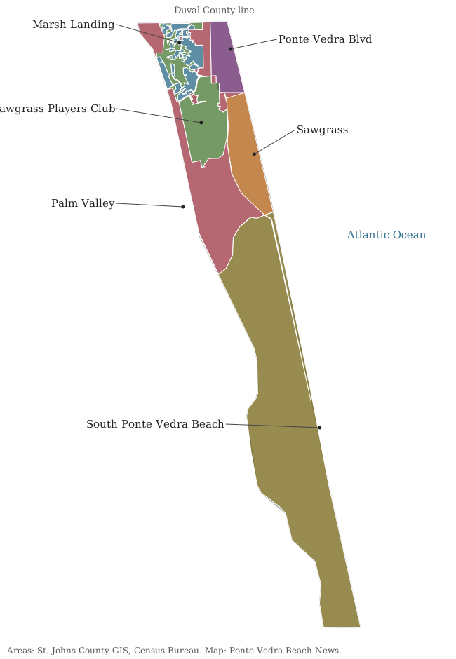
Our map is drawn from St. Johns County’s GIS layers and the Census Bureau’s TIGERweb boundaries. Road, store and place names on our pages come from OpenStreetMap, © OpenStreetMap contributors. The county’s own Ponte Vedra Zoning District map (PDF) shows that district’s boundary.
How we built this
- The areas come only from official or open maps. The Ponte Vedra Boulevard area is the part of the county’s Ponte Vedra Zoning District north of Sawgrass. Sawgrass and Palm Valley are the Census Bureau’s census-designated places, which OpenStreetMap also names. Marsh Landing and the Sawgrass Players Club are the outlines on the county’s map of registered architectural review associations. South Ponte Vedra Beach is the rest of ZIP code 32082, south of the Census areas, a name the county uses for that stretch.
- We left out names we could not place on an official map, and we did not split areas into individual subdivisions.
- Homes and school zones come from laying St. Johns County’s address points (residential and condo sites) over each area and over the district’s 2026-27 zone layer. Shares are of addresses.
- Parks, beach accesses and associations come from the county’s GIS layers; stores and place names from OpenStreetMap.
- Road distances were measured with the OSRM routing engine on OpenStreetMap roads from a named public place in each area. They are distances, not drive times.
- We do not rank areas or describe who lives in them.
Frequently asked questions
What are the neighborhoods in Ponte Vedra Beach?
St. Johns County and Census Bureau maps divide Ponte Vedra Beach into six areas: the Ponte Vedra Boulevard area in the Ponte Vedra Zoning District, Sawgrass, Marsh Landing, the Sawgrass Players Club, Palm Valley and South Ponte Vedra Beach.
What ZIP code is Ponte Vedra Beach?
- All six areas in this guide are in ZIP code 32082. The neighboring ZIP code 32081, mailed as Ponte Vedra, includes Nocatee, west of the Intracoastal Waterway.
Is Ponte Vedra Beach a city?
No. Ponte Vedra Beach is unincorporated, so St. Johns County is its local government. The Census Bureau counts parts of it as the Sawgrass and Palm Valley census-designated places.
What high schools serve Ponte Vedra Beach?
On the 2026-27 St. Johns County zone map, every home address in ZIP code 32082 north of about the 2700 block of South Ponte Vedra Boulevard is zoned for Ponte Vedra High. Addresses south of that are zoned for St. Augustine High. Both earned an A in Florida’s 2026 school grades.
What is the typical home value in Ponte Vedra Beach?
$851,499 in ZIP code 32082 in August 2026, up 2.0% from a year earlier, according to the Zillow Home Value Index. It is a modeled typical value, not a sale price.
Have your say