Rip currents are likely at Ponte Vedra Beach until 7 a.m. Monday, the weather service says. Surf runs 4 to 5 feet Sunday and Monday, easing to 2 to 3 feet by Veterans Day.
The high rip current risk is back at Ponte Vedra Beach. The National Weather Service in Jacksonville issued a new rip current statement for the Northeast Florida beaches early Saturday, Nov. 7. It runs until 7 a.m. Monday, Nov. 9.
Updated Nov. 8: The weather service issued the rip current statement at 12:53 a.m. Saturday and updated it at 12:56 p.m. “Rip currents can sweep even the best swimmers away from shore into deeper water,” it says. Its surf zone forecast issued at 5 p.m. Saturday rates the risk high Sunday and Monday, when “life-threatening rip currents are likely in the surf zone.” Surf is 4 to 5 feet both days, with northeast winds around 10 mph Sunday and water at 70 to 75 degrees. Surf eases to 3 to 4 feet Tuesday and 2 to 3 feet on Veterans Day. The county’s seasonal lifeguards work May through September, so most beaches have none on duty now.
Updated Nov. 5: The weather service canceled the rip current statement at 1:25 a.m. Thursday, a few hours before it was due to end. No new beach alert is in effect for the St. Johns County coast. Its surf zone forecast issued at 1:30 p.m. Thursday puts the rip current risk at moderate Friday, with surf of 2 to 3 feet. Surf builds to 4 to 5 feet Saturday through Monday, with northeast winds around 15 mph Sunday. A moderate risk still means “life-threatening rip currents are possible in the surf zone,” the forecast says. The county’s seasonal lifeguards work May through September, so most beaches have none on duty now.
Updated Nov. 4, evening: The weather service did not extend the high rip current risk again. Its surf zone forecast issued at 5 p.m. Wednesday keeps the statement ending at 4 a.m. Thursday. It forecasts a moderate rip current risk Thursday and Friday, with surf of 3 to 4 feet. Surf builds to 4 to 5 feet Saturday through Monday. At moderate risk, the forecast says, “life-threatening rip currents are possible in the surf zone.”
Updated Nov. 4: The weather service extended the high rip current risk once more. Its rip current statement issued at 9:23 a.m. Wednesday runs to 4 a.m. Thursday for the northeast and southeast St. Johns County coast. The surf zone forecast issued at 11 a.m. Wednesday calls for surf of 4 to 5 feet Wednesday. It drops the risk to moderate Thursday, with surf of 3 to 4 feet.
Updated Nov. 2: The weather service extended the high rip current risk again. Its statement issued at 1:25 p.m. Monday runs it to 4 a.m. Wednesday, Nov. 4. A high surf advisory for breaking waves of 5 to 7 feet runs until midnight Monday. The surf zone forecast issued at 5 p.m. Monday calls for surf of 4 to 5 feet Tuesday and a moderate rip current risk Wednesday. The coastal flood advisory was canceled at 1:02 p.m. Saturday, Oct. 31.
Updated Oct. 31: The weather service extended the high rip current risk to 7 p.m. Sunday in its statement issued at 2:22 p.m. Friday. Its surf zone forecast calls for surf of 4 to 5 feet Saturday and 5 to 7 feet Sunday. The coastal flood warning ended Thursday afternoon, and a minor coastal flood advisory runs to 5 a.m. Sunday. Read our coastal flood story for this weekend’s high tide times.
Updated Oct. 26: The weather service extended the high rip current risk again at 3:22 a.m. Monday. It now runs through late Wednesday night. A high surf advisory for breaking waves of 8 to 10 feet runs to 8 a.m. Wednesday, and the coastal flood warning to 2 a.m. Thursday. Read our coastal flood warning story for the new high tide times.
Updated Oct. 24: The rip current risk now runs to 8 p.m. Monday, Oct. 26. The weather service has also issued a coastal flood warning from 5 p.m. Saturday to 8 p.m. Monday. Read our story on the coastal flood warning for the alerts, high tide times and surf forecast. The coastal flood advisory below was canceled early Oct. 21, and the high surf advisory expired the same morning.
Updated Oct. 20: The high rip current risk, first set to end at 1 a.m. Tuesday, now runs through late Wednesday night. The surf and coastal flood advisories are new.
Oct. 20: extended through Wednesday
The National Weather Service in Jacksonville reissued its warnings at 9:56 a.m. Monday. They cover Northeast Coastal St. Johns, the zone that includes Ponte Vedra Beach. Three are in effect:
| Alert | What it means | Ends |
|---|---|---|
| High rip current risk | Dangerous rip currents | Late Wednesday night (4 a.m. Thursday, Oct. 22) |
| High surf advisory | Breaking waves of 7 to 10 feet | 8 p.m. Tuesday |
| Coastal flood advisory | Minor coastal flooding | 4 a.m. Thursday, Oct. 22 |
The weather service expects flooding of lots, parks and roads, with only isolated road closures. It also warns of localized beach erosion. It said: “Do not drive around barricades or through water of unknown depth.”
The surf zone forecast issued at 12:17 p.m. Monday lists Ponte Vedra Beach by name. It calls for:
- Tuesday: high rip current risk, surf 6 to 8 feet, north winds around 15 mph, sunny, highs in the mid 70s
- Wednesday: surf 6 to 8 feet, northeast winds around 15 mph, highs in the upper 70s
- Thursday: surf 5 to 7 feet, north winds around 15 mph
- Friday: surf 6 to 8 feet, northeast winds around 20 mph
High tide at Jacksonville Beach, about two miles north, is at 4:25 p.m. Tuesday, the same forecast says. That is the time to watch low-lying roads and dune walkovers.
How it started
The first statement ran from 6 a.m. Saturday. A strong cold front crossed the coast early Saturday. Behind it, gale-force north winds were expected to build the surf to 8 to 10 feet by Sunday, with significant beach erosion likely around high tide.
The weather service’s rip current statement covers the beaches from southeast Georgia to Flagler County. It names Northeast Coastal St. Johns, the weather service zone that covers Ponte Vedra Beach.
What the forecast said Friday
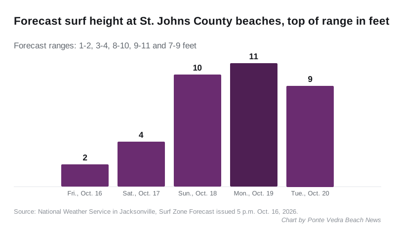
The surf zone forecast issued at 5 p.m. Friday lists Ponte Vedra Beach by name. It calls for:
- Saturday: high rip current risk, surf 3 to 4 feet, northwest winds 15 to 20 mph
- Sunday: surf 8 to 10 feet, north winds around 25 mph, highs around 70
- Monday: surf 9 to 11 feet, north winds around 20 mph
- Tuesday: surf 7 to 9 feet, north winds around 15 mph
High tide at Jacksonville Beach, about two miles north, is at 1:33 p.m. Saturday, according to the same forecast.
The weather service’s forecast discussion on Friday evening set out the wider picture. It expects:
- wind gusts of 30 to 40 mph at the coast from Saturday through Monday
- a gale warning over the Atlantic waters from 2 p.m. Saturday to 1 a.m. Tuesday, with seas building to 10 to 15 feet
- minor tidal flooding along the coast, the Intracoastal Waterway and the St. Johns River basin from Sunday, likely lasting until at least the middle of next week
- breakers of 8 to 10 feet at the northeast Florida beaches through at least Tuesday
The forecast for Ponte Vedra Beach has north winds gusting as high as 36 mph on Sunday, according to the weather service forecast for the area.
Lifeguards
St. Johns County Marine Rescue employs its seasonal lifeguards “during the summer months from May to the end of September,” according to the county’s Marine Rescue page. The county says Marine Rescue covers all 42 miles of its oceanfront.
What it means for you
- Stay out of the water if you are not a strong swimmer. The weather service says rip currents “can sweep even the best swimmers away from shore into deeper water.”
- If you are caught in one, the weather service says to relax and float, not to swim against the current, and to swim parallel to the shoreline if you can. If you cannot escape, face the shore and call or wave for help.
- Swim near a lifeguard, the weather service advises.
- Plan around the statement’s end. The high risk runs until 7 a.m. Monday, Nov. 9, and the surf forecast still rates Monday high. The weather service forecast for Ponte Vedra Beach carries the latest.
The current rip current statement ends at 7 a.m. Monday. We will update this story when the weather service ends or extends it.
Have your say