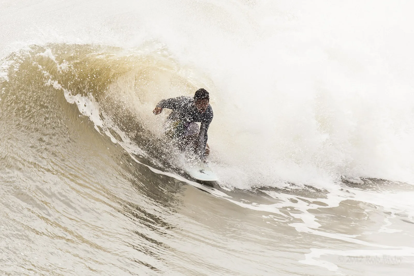
The Ponte Vedra Beach coastal flood advisory was canceled Oct. 31, ending flood alerts that began Oct. 20. The high rip current risk runs through late Tuesday, Nov. 3.
Coastal flood alerts for Ponte Vedra Beach have ended. The National Weather Service in Jacksonville canceled the last one, a minor coastal flood advisory, at 1:02 p.m. Saturday, Oct. 31. It had been due to run to 5 a.m. Sunday. Coastal flood alerts first went up Oct. 20. They included a coastal flood warning from Oct. 24 to Oct. 29.
The ocean is still dangerous. A high rip current risk runs to 4 a.m. Wednesday, Nov. 4, and a high surf advisory until midnight Monday. Read our rip current story for the surf forecast.
Updated Nov. 2: The weather service’s cancellation notice for Northeast Coastal St. Johns was issued at 1:02 p.m. Saturday. No coastal flood alert was in effect for the zone as of Monday evening. As of Monday, St. Johns County had posted no road closures or beach damage reports on its news page.
Updated Oct. 31: The warning ended Thursday afternoon, a week after it was first issued. The advisory and the rip current risk are set out in the Oct. 29 to 31 update below. As of Saturday morning, St. Johns County had posted no road closures or beach damage reports on its news page.
Updated Oct. 26: The weather service extended the warning at 3:22 a.m. Monday. It had been due to end at 8 p.m. Monday. The high surf advisory now runs to 8 a.m. Wednesday and the high rip current risk through late Wednesday night. The new alert times and high tides for Tuesday and Wednesday are in the Oct. 26 extension below. As of Monday evening, St. Johns County had posted no road closures or beach damage reports on its news page.
Oct. 29 to 31: warning ends, advisory to Sunday
The weather service shortened the warning twice before ending it:
- Wednesday, Oct. 28, 2:48 a.m.: extended to 2 a.m. Friday, Oct. 30.
- Thursday, Oct. 29, 2:56 a.m.: cut back to end at 2 p.m. Thursday, with a coastal flood advisory to follow.
- Thursday, Oct. 29, 1:56 p.m.: warning canceled; the advisory runs to 3 p.m. Friday.
- Friday, Oct. 30, 2:22 p.m.: advisory extended to 5 a.m. Sunday, Nov. 1.
The weather service’s latest coastal hazard message, issued at 2:22 p.m. Friday for Northeast Coastal St. Johns, lists:
| Alert | What it means | Ends |
|---|---|---|
| Coastal flood advisory | Minor coastal flooding around high tide | 5 a.m. Sunday, Nov. 1 |
| High rip current risk | Dangerous rip currents | 7 p.m. Sunday, Nov. 1 |
| High surf advisory | Breaking waves of 4 to 6 feet | Ended midnight Friday |
It expects “flooding of lots, parks, and roads with only isolated road closures.” Clocks fall back an hour at 2 a.m. Sunday, so both end times are Eastern Standard Time.
These are NOAA’s predicted high tides at Jacksonville Beach, about two miles north:
| Day | High tide | Predicted height |
|---|---|---|
| Saturday, Oct. 31 | 12:55 p.m. | 6.3 feet |
| Sunday, Nov. 1 | 1:27 a.m. | 5.1 feet |
| Sunday, Nov. 1 | 1 p.m. | 6.0 feet |
The weather service’s surf zone forecast, issued at 5 p.m. Friday for Ponte Vedra Beach, Palm Valley and Sawgrass, calls for:
- Saturday: high rip current risk, surf 4 to 5 feet, east winds 10 to 15 mph, a chance of showers
- Sunday: surf 5 to 7 feet, east winds around 15 mph, a chance of showers
- Monday: surf 4 to 6 feet, showers likely
Trick-or-treat hours and Halloween events are on our Halloween page.
Oct. 26: extended to Thursday
The weather service’s coastal hazard message, issued at 3:22 a.m. Monday, covers the Northeast Florida beaches. Three alerts are in effect:
| Alert | What it means | Ends |
|---|---|---|
| Coastal flood warning | Moderate to possibly major flooding around high tide | 2 a.m. Thursday, Oct. 29 |
| High surf advisory | Breaking waves of 8 to 10 feet | 8 a.m. Wednesday, Oct. 28 |
| High rip current risk | Dangerous rip currents | Late Wednesday night, Oct. 28 |
These are NOAA’s predicted high tides at Jacksonville Beach, about two miles north. The wind will push the water higher than these heights.
| Day | High tide | Predicted height |
|---|---|---|
| Tuesday, Oct. 27 | 9:17 a.m. | 6.8 feet |
| Tuesday, Oct. 27 | 9:37 p.m. | 5.4 feet |
| Wednesday, Oct. 28 | 10:07 a.m. | 6.9 feet |
| Wednesday, Oct. 28 | 10:28 p.m. | 5.3 feet |
The weather service’s surf zone forecast, issued at 11 a.m. Monday for Ponte Vedra Beach, Palm Valley and Sawgrass, calls for:
- Tuesday: high rip current risk, surf 7 to 9 feet, northeast winds around 20 mph
- Wednesday: surf 7 to 9 feet, northeast winds around 20 mph, highs in the upper 70s
- Thursday: surf 7 to 9 feet, a chance of showers
- Friday: surf 5 to 7 feet
How the warning began
Ponte Vedra Beach was first put under the warning from 5 p.m. Saturday to 8 p.m. Monday. The weather service issued it at 7:09 p.m. Friday, upgrading a coastal flood watch it had issued Thursday evening. It covers Northeast Coastal St. Johns, the forecast zone that includes Ponte Vedra Beach.
The high rip current risk has been in effect at Ponte Vedra Beach since Oct. 17. The weather service has extended it several times, most recently through late Wednesday night.
What was in effect over the weekend
Five alerts covered the Ponte Vedra Beach coast over the weekend, according to the weather service’s coastal hazard message and its wind advisory:
| Alert | What it means | When |
|---|---|---|
| Coastal flood advisory | Minor coastal flooding | Until 5 p.m. Saturday |
| Coastal flood warning | Significant coastal flooding | 5 p.m. Saturday to 8 p.m. Monday |
| High surf advisory | Breaking waves of 7 to 11 feet | 8 a.m. Saturday to 8 p.m. Monday |
| High rip current risk | Dangerous rip currents | Through Monday evening |
| Wind advisory | Northeast winds of 15 to 25 mph, gusts to 40 mph | Noon Saturday to 1 a.m. Sunday |
In Coastal Duval County, which includes Jacksonville Beach, the coastal flood warning starts earlier, at 5 a.m. Saturday.
The weather service lists these impacts for the warning:
- numerous roads may be closed
- low-lying property, including homes, businesses and some critical infrastructure, will be inundated
- some shoreline erosion
- dangerous swimming and surfing conditions and localized beach erosion
Why the water is so high
St. Johns County Emergency Management set out the cause in a release Friday. Strengthening northeast winds are arriving with “the highest astronomical tides of the year.”
The county said the weather service’s Friday morning briefing forecast moderate to locally major tidal flooding. That covers the Atlantic coast, the Intracoastal Waterway and the St. Johns River basin. The greatest concern is Saturday through Monday, around high tide. Peak wind gusts of 35 to 45 mph are expected Sunday into Monday, the county said.
The weather service’s forecast discussion on Friday night said a high risk of rip currents and significant beach erosion could last through much of next week. It also expects gale conditions over the Atlantic waters through at least Monday.
Weekend high tide times
Flooding is worst around high tide. These are NOAA’s predicted high tides at Jacksonville Beach, the nearest tide station, about two miles north. The predictions are for the normal tide only. The wind will push the water higher than these heights.
| Day | High tide | Predicted height |
|---|---|---|
| Saturday, Oct. 24 | 7:09 a.m. | 6.1 feet |
| Saturday, Oct. 24 | 7:25 p.m. | 5.5 feet |
| Sunday, Oct. 25 | 7:48 a.m. | 6.5 feet |
| Sunday, Oct. 25 | 8:05 p.m. | 5.5 feet |
| Monday, Oct. 26 | 8:31 a.m. | 6.7 feet |
| Monday, Oct. 26 | 8:49 p.m. | 5.4 feet |
Heights are in feet above mean lower low water, NOAA’s usual tide datum. The morning tides are the higher ones, and they rise each day to Monday.
The beach forecast
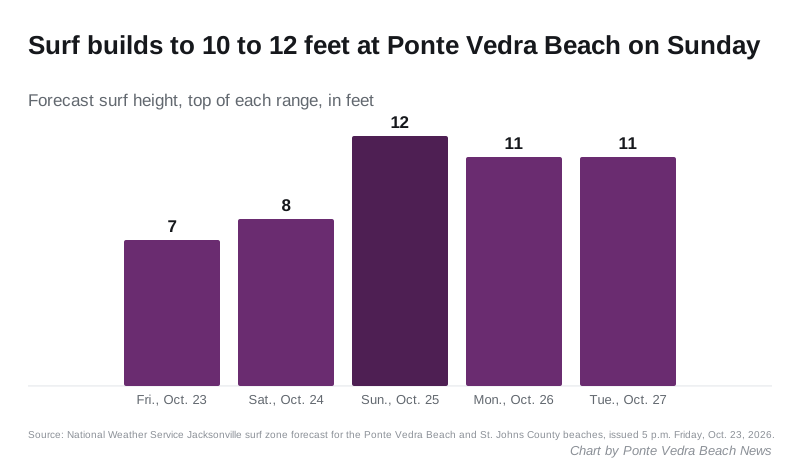
The weather service’s surf zone forecast, issued at 5 p.m. Friday, names Ponte Vedra Beach, Palm Valley and Sawgrass. It calls for:
- Saturday: high rip current risk, surf 7 to 8 feet, northeast winds 20 to 25 mph, showers likely
- Sunday: surf 10 to 12 feet, northeast winds around 25 mph, highs in the mid 70s
- Monday: surf 9 to 11 feet, northeast winds around 25 mph
- Tuesday: surf 9 to 11 feet, northeast winds around 20 mph
The forecast for Ponte Vedra Beach has northeast winds of 18 to 28 mph on Saturday, gusting as high as 40 mph. Showers and thunderstorms are likely Saturday afternoon and night, with a quarter to half an inch of rain possible overnight.
What it means for you
St. Johns County Emergency Management and the weather service ask people to:
- Never drive through floodwater. Turn around and find another route. The weather service says not to drive around barricades or through water of unknown depth.
- Avoid flood-prone areas around high tide, especially low-lying land along the ocean and the Intracoastal Waterway.
- Stay out of the surf. The weather service says rip currents “can sweep even the best swimmers away from shore into deeper water.” If you are caught in one, relax and float, and swim parallel to the shore if you can.
- Keep Halloween decorations, patio furniture and trash cans secured while the northeast winds continue.
- Postpone boat trips. The county said gale conditions were possible offshore Saturday through Monday, and the surf stays at 7 to 9 feet through Thursday.
- Sign up for Alert St. Johns, the county’s emergency notifications, on the Emergency Management page.
Our power outages page has the numbers for reporting a downed line. Our road construction and closures page lists the agencies that post road closures, and our hurricane prep page shows how to look up your evacuation zone.
How the rip current risk began on Oct. 17 is covered in our earlier story. We will update this story when the weather service changes or ends the advisory.
Have your say